

Islands Around Hokkaido (10)
カテゴリーページ
Click Link, Image or Button to View Category Posts
 情報追加
情報追加
 ホームページ >
 Homepage >
Reibun Island; Rishiri Island; Kunashir Island; Etorofu Island
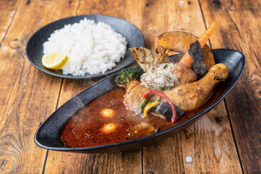
UNBALLON Soup Curry Dining (Rishiri Island) Closed
Closed Phone: 080-9614-1470 Address: 60-7, Fujimicho, Kutsugata, Rishiri, Rishiri District, Hokkaido 097-0401 Open: 11:30am to 2pm then 6pm to 10pm Closed: Wednesday URL: https://www.instagram.com/unballon_soupcurry/ GPS: 45.184296807584026, 141.1363615158208 (Google Maps) Service options: Dine-in · Takeaway · No delivery Rishiri Island Kanrosensui Spring (Rishiri Island) Ponyama / Mt. Pon (Rishiri Island), Hokkaido, Japan Soya Subprefecture The Horonobe Tonakai Reindeer Ranch/Farm Cape Soya (Soya ... Read more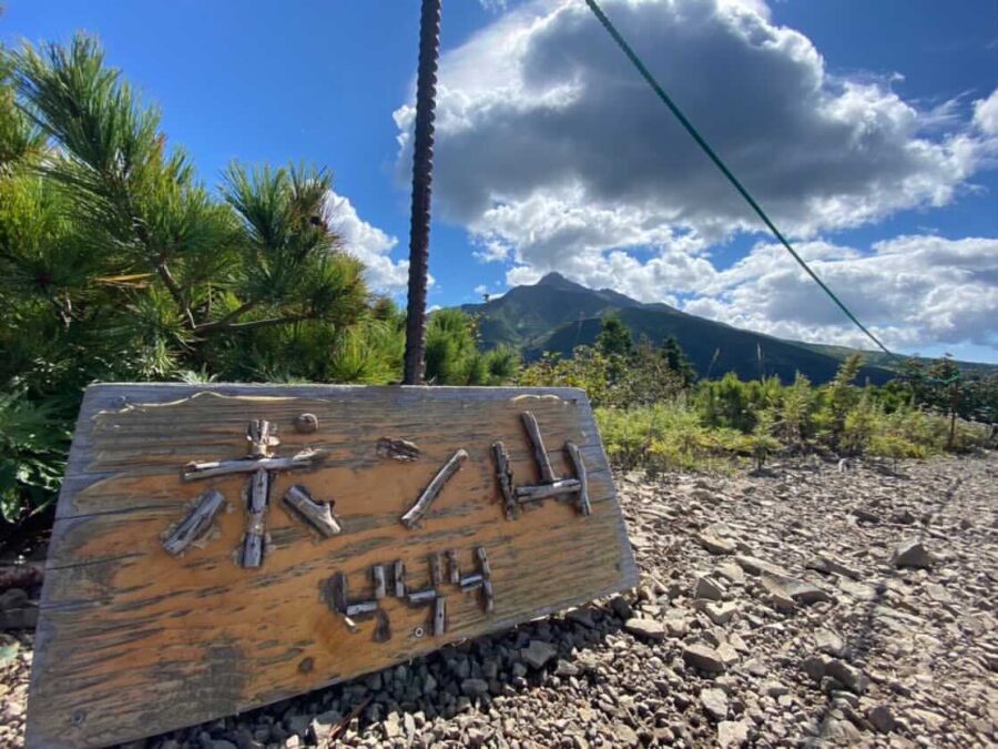
Ponyama / Mt. Pon (Rishiri Island), Hokkaido, Japan
Mt. Pon and Kanrosensui Course Address: Rishirifuji Town, Rishiri District, Hokkaido 097-0100 GPS: 45.22392961576974, 141.21954545860714 (Google Maps) Course Outline This course takes you from the trailhead (Hokuroku Camping Ground), past the Ganro fountain, to the Ponsan course from the Himenuma junction, and around the Little Ponsan and Ponsan mountains. The view from the 444-meter-high Mount ... Read more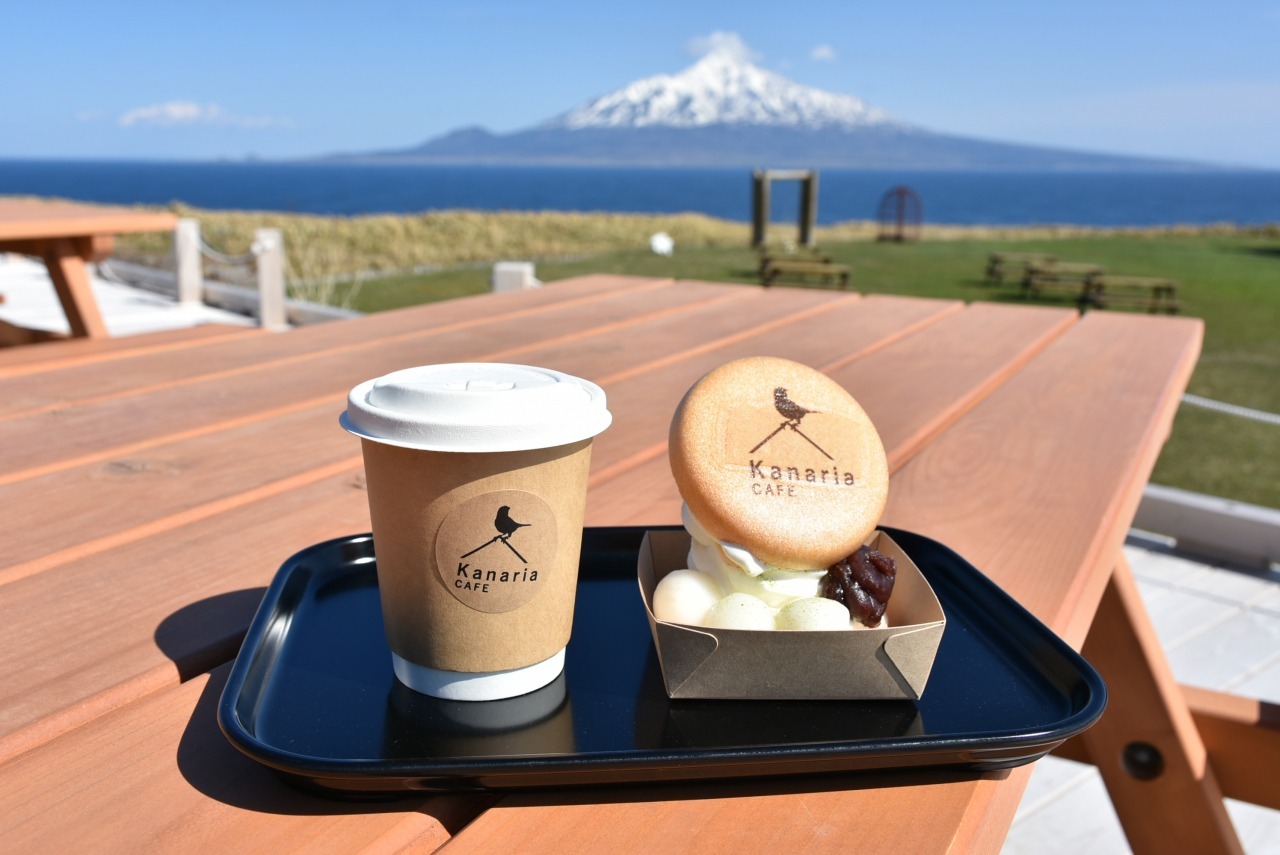
Kanaria Park Cafe, Rebun Island
Phone: 0163-86-1001 Address: 字フンベネフ671 北のカナリアパーク Kafukamura, Rebun, Rebun District, Hokkaido 097-1201 Open: 10am to 12:30pm then 1pm to 4pm (L.O. 3:30pm) Takeout till 4pm URL: https://www.town.rebun.hokkaido.jp/hotnews/detail/00000171.html For The Taxi Driver: 〒097-1201 北海道礼文郡礼文町香深村字フンベネフ671 北のカナリアパーク GPS: 45.27762447923392, 141.04148339144893 (Google Maps) Places To Visit Around Soya Subprefecture, Hokkaido, Japan Kanrosensui Spring (Rishiri Island) The Horonobe Tonakai Reindeer ... Read more
歯舞諸島(はぼまいぐんとう)
島の一覧 島名 Japanese Name Russian Name Ainu Name Area km2 Highest point m Latitude N Longitude E Distance from Cape Nosappu km 色丹島 Shikotan 色丹島 しこたんとう Shikotan tō Остров Шикотан Si-kotan (Big village) 255 412.6 43°47' 146°44' 73.3 principal marine products being cod, crab, and kelp GPS: 43.80309051967712, 146.74656631042993 Spangberg Channel(Habomai islands are shown below.) Shikotan Channel 海馬島 - ... Read more
Yagishiri Men Hitsuji Ranch
Yagishiri Sheep Ranch is located on a hill that climbs a gentle slope from the port. The sea is so close that you can hear the sound of the waves hitting the rocks. There is a dormitory and a sheep's stable near the entrance, and beyond that there is a grassland as far as the eye ... Read moreHabomai Islands (Visa Needed)
List of islands Island Japanese Name Russian Name Ainu Name Area km2 Highest point m Latitude N Longitude E Distance from Cape Nosappu km Shikotan Shikotan 色丹島 しこたんとう Shikotan tō Остров Шикотан Si-kotan (Big village) 255 412.6 43°47' 146°44' 73.3 principal marine products being cod, crab, and kelp GPS: 43.80309051967712, 146.74656631042993 Spangberg Channel(Habomai islands are shown below.) Shikotan Channel ... Read more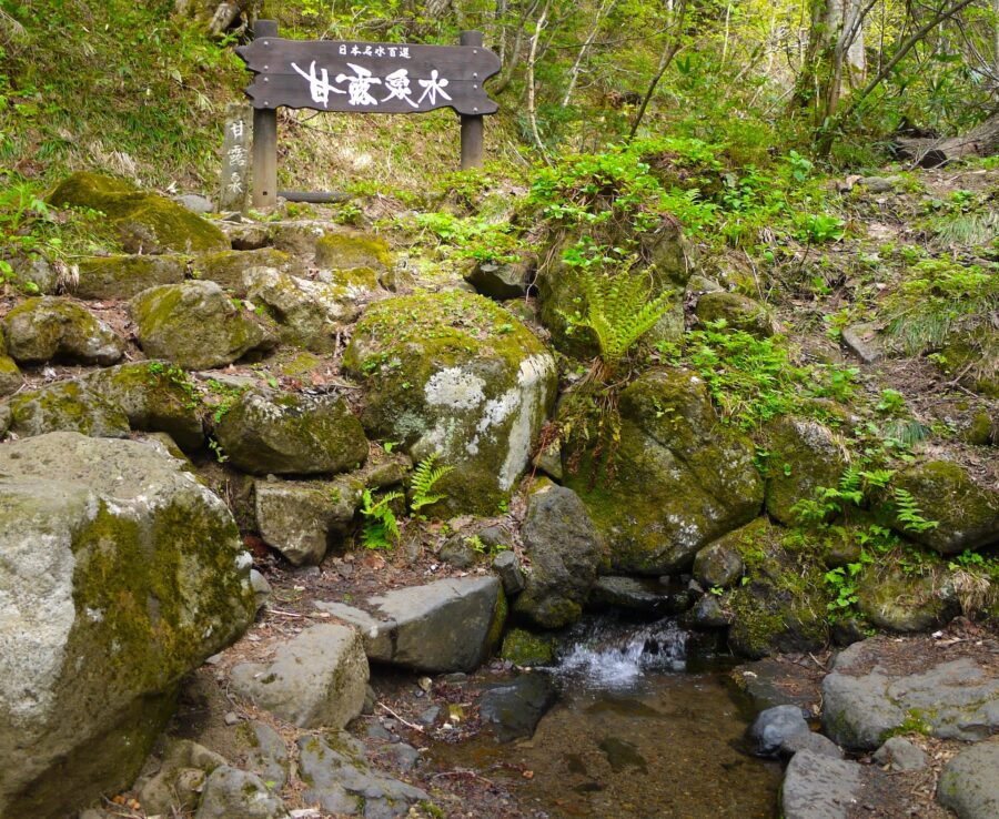
Kanrosensui Spring (Rishiri Island)
Kanrosensui Course Address: Rishirifuji Town, Rishiri District, Hokkaido 097-0100 Course Outline This course takes you from the trailhead (Hokuroku Camping Ground), to the Kanro fountain. GPS: 45.22077332138965, 141.21688759617734 Rishiri Island UNBALLON Soup Curry Dining (Rishiri Island) Closed Ponyama / Mt. Pon (Rishiri Island), Hokkaido, Japan Soya Subprefecture Okhotsk Museum Esashi Kanaria Park Cafe, Rebun Island ... Read more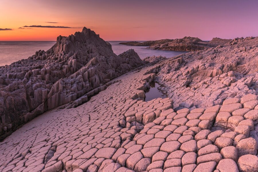
Cape Stolbchaty, Kunashir Island (Visa Needed)
Cape Stolbchaty on the eastern side of the Kunashir Island. GPS: 44.02542696671918, 145.6765122403166 Nature Nijukken Road / Hokkaido Tenjinyama Park Sunflower Maze Sankakuyama Ubaranai SANGO Grassland Wind Garden Furano Mishima San's Garden, Kutchan, Niseko Ponyama / Mt. Pon (Rishiri Island), Hokkaido, Japan Toyokoro Jewel Ice Kamui Rock, Cape Kamui Itanki Beach, Muroran Shimamui Coast, Shakotan Kanrosensui ... Read more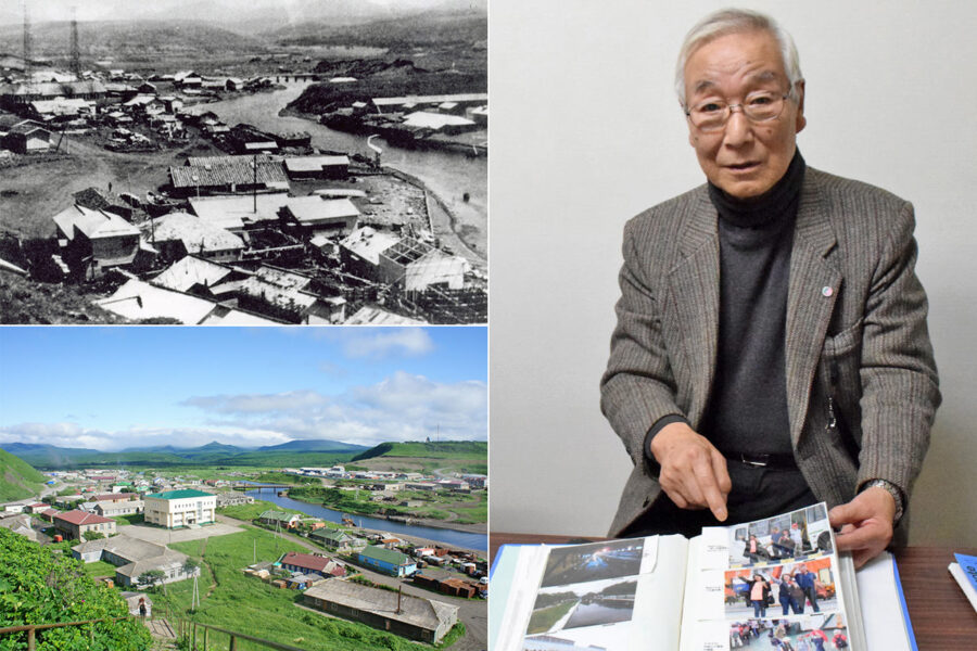
Etorofu Island, Shana Village (Visa Needed)
(Upper left) Shana Village (択捉島紗那村) in pre-war days. (Lower left) Current view of the same photo as above. (Right) Mr. Tadaaki Iwasaki (岩崎忠明), a former islander GPS: 45.229253865539874, 147.87380375356503 Late spring when all the flowers are in bloom Mr. Tadaaki Iwasaki, 82, who now lives in Sapporo, was born and raised in Shana Village on ... Read more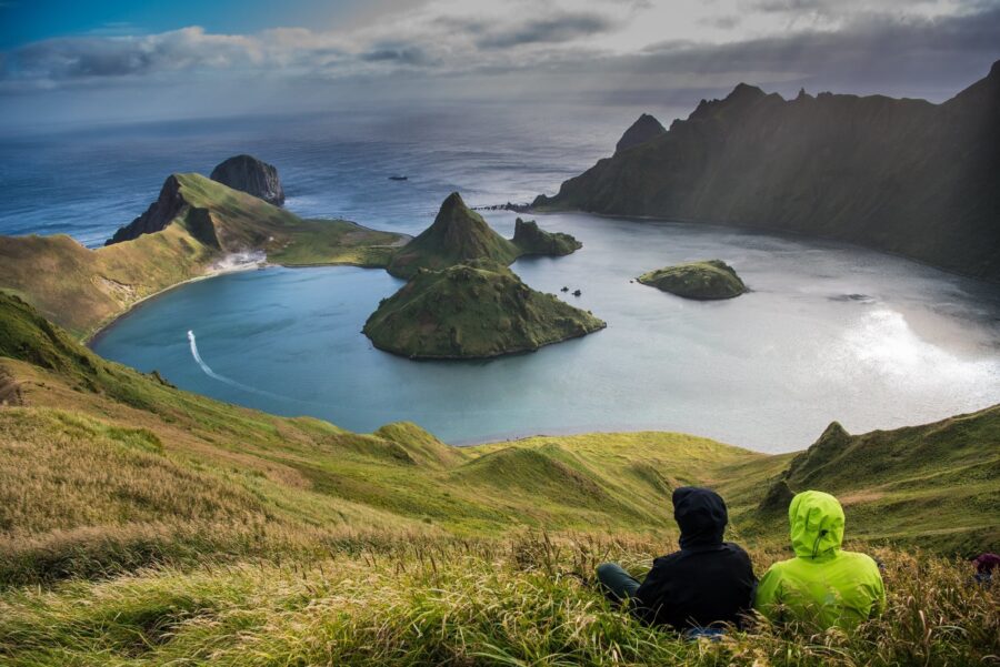
Kurilskiy State Nature Reserve (Visa Needed)
Phone: +7 424 55 21 502 (Reserve Administration) Address: 5 Zarechnaya St., Yuzhno-Kurilsk, Kuril Islands, Russia 694500 Ecological Education and Ecotourism Department kurilskiy @ mail.ru or kurilskiy @ gmail.com https://peakvisor.com/park/kurils-nature-reserve.html GPS: 44.098971444493976, 145.8991962119183 Golovnin Volcano Yankicha Island, Kuriles. Photo: Vladimir Klyushkin Most popular sites to visit are: Golovnin Volcano Caldera Tyatya Volcano The Pillar Cape (Stolbchaty Cape) ... Read more応用並べ替えフィルターSearch Filter Applied:
 Contact Us